|
| Return to paradise |
When we reached Imperial beach last week, the proximity of Mexico really became palpable in a way that it had not been previously. Last night as planned for the weekend the possibility of making it to the border began to take shape. It would be a longish day and dealing with the mouth of the Tijuana river would be interesting given that low tide was expected to occur around 4:45 that afternoon, but what the heck we could try.
 |
| The colorful plastic sculpture of Imperial beach |
Imperial Beach boasts that it is the Southwestern most city in the US and the southernmost beach town on the us mainland. It is also one of the last affordable beach towns left and the vibe here is thoroughly middle class. In contrast to last week it was sunny with highs in the 70's. In some way not so different from the first day of our journey, but a bit cooler and a lot drier. Otherwise it was another sunny day. People blissing on the beach. We've been in the midst of a crippling drought. indeed I wouldn't have considered trying to cross the Tijuana river on foot had there been any rain in the past few weeks, but there really hasn't so I think it's safe enough. Today we could see all that had been obscured the previous week: Coronado, Downtown, the mountains of Mexico, the Coronado Islands. Totally remarkable.
 |
| Under the pier |
 |
| Looking back north to our bright blue city |
 |
| Point Loma very visible today |
 |
| Ahh a typical summer day, but it's January |
 |
| IB Pier |
I
 |
| I like the lineations here, |
 |
| This was the only lifeguard tower I saw |
 |
| Surfer with the Coronado Islands in the background |
 |
| colorful cottages |
Imperial Beach in some ways reminded me of South Oecanside or maybe Mission Beach, with the beach houses right up against the sand, and lots of little passageways between them. Unlike those resort areas, however the houses here seem a bit less expensive, the population less dense. It is a backwater of a beach town, the end of the road. The beach road to the south is abuts the Tijuana River wetlands and comes to a dead end a bit north of the river mouth. There is the perception also that the Tijuana river is quite polluted, and as a consequence the sea here as well, however I did get some assurance from a guy who studies point source pollution that as long as there hadn't been any rain recently I'd be fine. It's also a long way from things here. Certainly Bustling downtown Tijuana is only 6 miles away as the crow flies, but the international border along with the wetland is a major logistical hurdle. Downtown San Diego is also still quite a trek from here even in good traffic. All of the South Bay is kind of San Diego that San Diego forgot. Plenty of population, plenty of nice places, but somehow much farther from the tourist radar.
 |
| More sculptures of some not so bygone era |
 |
| The Sea theme for this cottage. |
 |
| Pier now getting faraway. |
 |
| Many footsteps. |
 |
Looking out across the Tijuana river wetlands toward the mountains
of Mexico. |
 |
| The beginning of similar homes. |
 |
| back from where we came |
 |
| Anita on the way. |
 |
| the houses that all look the same. |
You'd expect the southernmost segment of developed coastline to have a bit more flare and pizzaz, but instead there are just some unassuming condo complexes. I have at times railed against the whole tract homes, as unoriginal, and blight, yet alter I grew to understand that perhaps such was coming from a place of priviledge and that the cost savings of tract homes allowed more people to afford the American Dream. Now I'm not sure, development is a huge habitat threat. and it seems the worst of these tract homes weren't for working class folks anyway. Perhaps if real wages were what they were a few decades back people could afford to be more individualistic. But we have more population pressure now and bad developments are just a symptom of a larger imbalance in our society. Anyway after seeing the way the beach houses in mission beach were built with fancy facades proclaiming the life of leisure and seaside palaces of La Jolla, it's kind of refreshing to see some humility in coastal architecture. The southernmost house on the US mainland west coast looks very much like its neighbors, it jst doesn't have any neighbor to the south.
 |
| The Southernmost house on the US mainland west coast |
 |
| Rounding the point, Mexico comes into view |
We were now rounding a bit of a point and soon Mexico was coming into view. We were not sure if we'd have the energy to make today, but with the bull ring already so large in the horizon, it seemed like a little effort for a lot of reward. As got passed the last of the homes and the end of the road, the crowds thinned out even more. While we did not exactly have the beach to ourselves there were vast stretches of shore where only a few seemed to be.
 |
| Shimmerin seas |
 |
| looking for a lunch spot |
 |
it seems the point has provided a bit of shelter.
Fewer surfers here smaller waves. |
 |
| waves |
 |
| Sometimes lunch is outright decadent |
 |
| And those mountains of mexico seem so much closer. |
 |
| neat little sand sculpture |
 |
| Metal detector men. |
The ridge of sand separating the estuary from the ocean lowers (It looks like they have some levee to keep the river outflow from migrating too far north. The sand broadens and the crowds become even more sparse. The Tijuana River wetlands are the largest intact coastal wetlands left in Southern California. They provide immeasurable benefit to the surroundings, acting as a natural filter for pollution, flood control, wildlife habitat. It becomes quite the wilderness here for how close we are to the city.
 |
| Wildlife at the mouth of the Tijuana River |
 |
| Broad tidal flats |
 |
| Fire helicopter |
 |
| Lovely textures to the land |
 |
| Sky reflected in the water |


One of the things I love about this beach is the way the landforms at the mouth of the river emerge as the tide goes out. Broad rippled surfaces, little tidal ponds, reflections, mouth bars. We were actually depending on some of these to help us walk across the river mouth as the tide went out. Across the way a young couple was trying to come across as well and clearly struggling. When there hasn't been much rain most of outflow here is just stored lagoon water, but given the size of the lagoon, the current is quite stiff. The tide was dropping by the minute and it was had to find a place where I wasn't going to get swept away. Anita and I almost turned back at one point, but then the couple on the other side found a way across and it seemed like soon the tide would be low enough for us as well (Anita was trying to avoid getting her shorts wet). As I was encouraging Anita to wait for the tide we did indeed see a woman get across with the water only up to her knees. in the end it was the mouth bar that was our savior.

 |
| Here comes the horseback riders |
 |
| I am not actually naked in this picture |
 |
The Horseback riders tell the woman in the Bikini top that the water
is not exactly clean. She found a way across. |
Despite the marsh, the Tijuana River is actually not very clean. It drains one of Mexico's largest cities just a few miles up the way and my understanding is that the enforcement of clean water standards for what ends up in the river are not very well enforced, and there is a bit of a legacy pollution from recent industrialization efforts there. It is not to say there are not efforts underway to improve the situation, just that it's not there yet. Of course just a week ago some jerkwad company in West Virginia dumped a bunch of toxic chemicals into the water there and is now declaring bankruptcy to get out of compensating the 300,000 people who were without clean drinking water. Seriously something has got to give this is not a situation that is workable for society.
 |
| One more shot. |
 |
| Booyeah! I made it across the river! Now I'm coming for my lady. |
 |
| The lonely shores of Border Field State Park |
 |
| Anita finding a sand dollar. |
 |
| Anita's reflection in the sand |
 |
| I love these holes that appear as the tide goes out |
Border field is the southernmost beach in California. At the end of a long dead end road, (that is usually closed because of perpetual flooding) It is primarily a destination for horseback riders and border patrol guys on 4X4's and AWD pickup trucks. A lovely stretch of sand where one almost always has the place to themselves and can stretch out and feel at one with ocean and sand and wildlife. With the tide going out I did my best impersonation of Jesus, walking on water. When I was younger and had long hair and was a touch skinnier, people used to say I looked like Jesus or John Lennon. Not so much now, but that's okay.
The feeling of the destination and impending accomplishment was now palpable. The glorious weather, sparkling water and lovely air gave the feeling of a triumphant entry. Are we changed by this?
 |
| So close |
I rejoined the mainland to be by Anita's side for the last 1/2 mile. I could barely contain the excitement. The signs in spanish were now readable, we could make out the apartment complexes and highways of the foreign land. In one sense it is not so different, and yet it is very much another country.
 |
| Love the way these little ones walk |
 |
| Sky |
 |
| Monument Mesa and the lighthouse |
 |
| The border fence |
 |
| Pelicans riding the waves |
 |
| Monument mesa on the US side |
 |
| We made it! |
 |
| Do a happy dance! |
 |
| There is Mexico |
 |
| The border goes out into the sea |
The Border fence at the beach is one of the truly unique places in San Diego. You notice so much while you're here. The border patrol are watching you like a hawk, but are mostly concerned with smuggling and illegal crossing so passing a canteen back and forth will not arouse as much suspicion as it would on a place like Mission Beach. On the US side you have one of the wildest, least crowded beaches in the county, abutting a massive wetland. On the Mexican side there's quite a crowd and its a thoroughly urban environment there. In a friendlier time people from the US and Mexico could mingle more freely, or at least exchange goods through the fence (technically illegal, but they used to turn a blind eye to the purchase of a popsicle through the bars). Now there's something of a 30 foot buffer zone and Border patrol types enforcing it quite aggressively (I think they'd probably give us a stern talking to if we got any closer, but still I'd rather not challenge the power today). It is still true that plenty of people cross the border somewhere along the frontier every day illegally looking for better opportunity. I always think that if socioeconomic conditions were to improve in Mexico, illegal crossings would cease to be an issue. yet here we are about to invest a substantial amount of money into even bigger scarier fences of dubious efficacy. Y People seem to be having more fun on the other side of the fence, though I'm not sure if the Playas de Tijuana crowd is exactly a representative sample of the population. I watched seagulls and pelicans fly around and over the fence clearly aware that it was not a natural barrier.
 |
| There's a platform where folks in Mexico can look out upon the US. |
 |
| WHoah! |
 |
| These birds do not see a barrier. |
 |
| Dude! the Border patrol is seriously watching this location! |
 |
| The border continues inland |
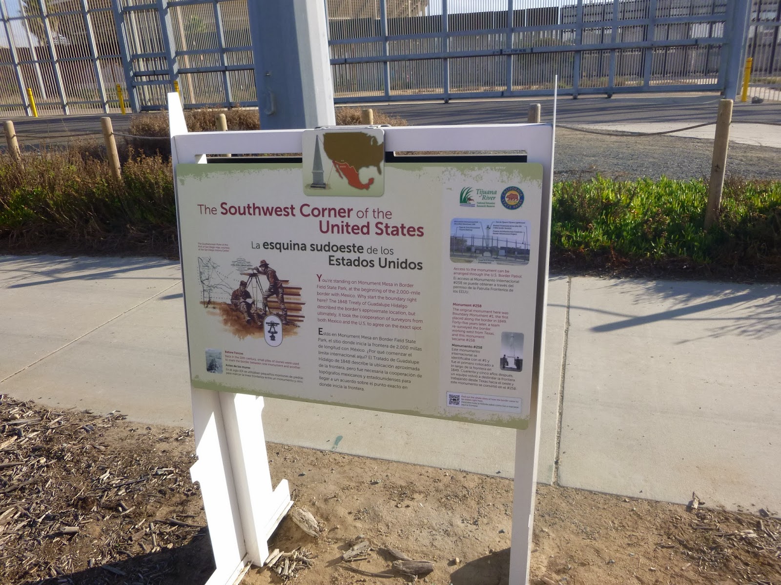
We decided to head up to Monument Mesa. It affords a nice view of the wetlands and has quite a bit of history, dating back to early border surveys. the border runs slightly Northeast of due east from here, making this beach the southernmnost place in California. The Monument has the westernmost border monument between US and Mexico, dating back to a time when the border was marked with stone Cairns. This monument was once surrounded by friendship park, which now is wholely enclosed by a second fence. It is a most unfortunate loss.
 |
| Sometimes the fence can be pretty |
 |
in friendlier times you could walk up to the fence here
and visit with folks in Mexico |
Due to flooding on the road leading over here, this US side of the park gets remarkably few visitors. In places it seems as if the vegetation is reclaiming the park and its picnic tables. We saw one other couple here on bikes. Otherwise it is all falling into disuse and disrepair. Is this the face of our nation?
 |
| The very empty park |
 |
| We have come a long way baby |
We gazed a bit upon all the land from which we had been wandering. From here we could see up the coast to Coronado and Point Loma, Further afield we could see the summit of Soledad. It occurs to me now that Soledad is the one place that can be viewed from the nearly the entire coast on a clear day, and that's pretty awesome. The park has a lot of new displays touting the history, natural and cultural that shaped this amazing and rarely visited locale. We inspected all of them and then made our way back down the mesa and began the journey home.
 |
| Not a lot of traffic |
 |
| Such a lovely place such a lonely place. |
 |
| Bustling Mexico. |
 |
| Returning to the shore. |
We made better time heading north, the tide now way out and approaching nadir. On the sand Bars I spotted numerous hermit crabs occupying former snail shells. Surprisingly easy to pick up as if they are defending themselves not so much from us, but other predators. The one fellow I did pick up was way too cute anyway.
 |
| hermit crab! by the sea by the sea by the beautiful sea |
Crossing the Tijuana river mouth was much easier now with lowering tide decreased current and water up just above the ankles. Broad exposed sand everywhere, the sky all sorts of colors as we entered the golden hour. With it so dry we knew it would cool off fast and we had been walking awhile now and I was wet. so we did not linger.
 |
| It was a bit easier going this way. |
 |
| lovely water rolling |
 |
| I'm coming! |
 |
| Love this complex evolving landform |
For the last bit we climbed atop the Levee and gazed at all the wilderness from which we were now emerging. As we approached the housed I saw a woman in a wedding dress and her photographers. It makes me happy always to see such expressions of love and the air did love her so. Given that the wedding party was connected to one of the condos, i suspect they are in fact vacation rentals.
 |
| Sky swirling in many colors |
 |
| A mist descends upon the isles. |
 |
| The air does truly love the Mademoiselle. |
 |
| Sky to my discredit stays beautiful |
So I picked up the bike at the beginning of the road and then rode to where I parked the car, saving us maybe a mile or so. Here we see so many sunsets. This one gave us maybe 10 minutes of amazing golden light upon all around us, then faded into darker more complex colors that provided only a backdrop against the darkness. As I was biking on a nearly flat back tire I and in a hurry I did not photograph the peak of sunset, but I will remember it richly.
 |
| Add caption |
It seemed appropriate to celebrate our accomplishment with some fish and chips and a beer at the pier. The Tin fish I must say however was a tad disappointing for how much it costs. I certainly understand the charm and joy of a tourist trap, but it feels like they could put a little more energy into making this place a tad nicer and the benefits would outweigh the costs, like hiring an extra line cook / table delivery person, or having sufficient ketchup on hand, or maybe widening the windows facing the ocean. I've been to comparable places like Sportsman's seafood and paid less and had better service. I've been to places like South Beach Bar and Grill in OB and been far happier in all categories for the same prices. Darn shame. Anyway we had fun, but probably won't come back to dine here, though the view at night was totally sublime. The lighthouse of Tijuana and the city across the border. Though it was also cold and we were tired so we did not linger, but instead went home for some well deserved rest.

So we've done it! What's next? Well we have a pass to all the Balboa Park Museums so we are thinking of hitting up a few, but for a journey we thought it might be good to travel the San Diego River. Stay tuned and thanks for all your love, support and fandom.